Currently
N/A°F
in De Luz, California, USA

N/A°F / N/A°F
N/A
N/A
Wednesday, April 30, 2025 8:16 AM PDT
De Luz
Currently
Forecast
Past Weather
Climate
Last 36 Hours
Weather News
Features
F.A.Q.
Contact Us
Use °C/Metric
 RSS Feed
 Follow UsWeatherCurrents
Local Roundup
Mobile Access
On Your Site
Follow UsWeatherCurrents
Local Roundup
Mobile Access
On Your Site
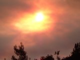
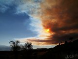
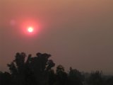
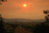
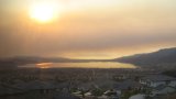
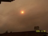
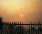
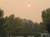
Photos of Smoke and Ash From October's Esperanza Fire
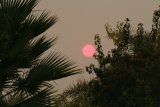
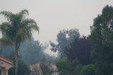
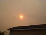
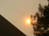
Posted December 17, 2006, 6:42 PM.Better late than never, here are a bunch of photos taken in various western Riverside communities during the first two days of the Esperanza Fire. We apologize for their lateness. They show the western part of Riverside county under dense smoke and ash for the better part of two days. The Esperanza Fire was the most devastating wildfire in Riverside County this year and in recent memory, and the top weather story of 2006 in the area. The fire began in the early morning of October 26th. Five firefighters died, 34 houses were destroyed and 40,200 acres were burned. The fire was caused by arson, and Raymond Lee Oyler was arrested and charged with arson and murder. Those charges are still pending trial. Tom Chester reports on the first day of the fire at his web site, including a panorama photo of incoming smoke taken at the intersection of Highway 79 South and Butterfield Stage Road, in Temecula. A Wikipedia entry captures the fire story. The photos are courtesy of Tim Young, Debbie Brookshier, Mike Wilson, Ara Witmer, Keith Schumacher, Jinwu Ma, Donna Blackmon, Stan Fader, Stephen Conley, Doug Leany, L. Grijalva and Dave Norton. Hemet

Murrieta
Lake Elsinore
Temecula
|
Other Recent Weather News for De Luz, California
|