Currently
N/A°F
in De Luz, California, USA

N/A°F / N/A°F
N/A
N/A
Wednesday, April 30, 2025 8:16 AM PDT
De Luz
Currently
Forecast
Past Weather
Climate
Last 36 Hours
Weather News
Features
F.A.Q.
Contact Us
Use °C/Metric
 RSS Feed
 Follow UsWeatherCurrents
Local Roundup
Mobile Access
On Your Site
Follow UsWeatherCurrents
Local Roundup
Mobile Access
On Your Site
Santa Rosa Plateau Ecological Reserve Photos
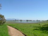
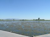
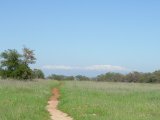
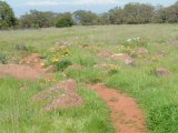
Posted March 23, 2005, 9:35 PM.The Santa Rosa Plateau is home of some of the last remaining natural vernal pools in Southern California, which are swollen this year with more than fifty inches of rainfall. Michael Mojarro visited the Santa Rosa Plateau Ecologicial Reserve earlier this month after it reopened and took the photos that follow this story. The reserve had been closed for much of January and February due to the heavy rains. Many of the trails remain heavily damaged, impassable or even destroyed. The reserve's web site chronicles much of the trail damage. In addition to the vernal pools (seasonal ponds that feed an entire ecosystem), wildflowers are currently in unusually full bloom this year on the plateau, as they are all around the region. Some of the featured photos on WeatherCurrents' Murrieta site showcase wildflowers from the reserve. The Santa Rosa Plateau Ecological Reserve is located just west of Murrieta, up Clinton Keith Road. Santa Rosa Plateau Ecological Reserve
|
Other Recent Weather News for De Luz, California
|