Posted March 24, 2011, 1:41 PM.
A fast-moving storm, the second of a young spring, blew through the region Wednesday night and early Thursday morning. Two more storms are due before the unsettled weather lifts early next week.
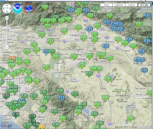
Rain totals from the storm ranged from 0.27" in Riverside to 0.66" in Lake Elsinore. The rainfall forecast was for between a quarter and a half of an inch in the inland valleys.
Scattered showers preceded the main front. Most of the rain fell in the evening hours, between 7:30pm and 11pm, with scattered showers lasting past midnight. Some communities had 0.01" for Thursday, and the rest had only trace amounts.
Other significant totals were in De Luz (0.66"), Wildomar (0.56"), Murrieta (0.55"), Fallbrook (0.45"), Temecula (0.44") and Menifee (0.40"), as the storm favored the southern areas of the inland valleys.
With the jet stream sagging south, two more storms were scheduled to arrive in Southern California by the end of the weekend. The next storm is predicted for tonight, and could add another quarter to a third of an inch to what has ended up being a wetter than usual March, the wettest since 2006. Another storm on Saturday night could add a tenth of an inch of rain.
WeatherCurrents' San Jacinto site was in the middle of a prolonged outage and was not operational during the storm.
The following rainfall totals were recorded Wednesday evening through Thursday morning:
| Location |
Storm |
Season |
Source |
| Lake Elsinore |
0.66" |
23.48" |
WeatherCurrents |
| De Luz |
0.65" |
30.52" |
WeatherCurrents |
| Wildomar |
0.56" |
18.66"1 |
WeatherCurrents |
| Northwest Murrieta |
0.55" |
19.78" |
WeatherCurrents |
| South Fallbrook |
0.46" |
22.97" |
WeatherCurrents |
| South Temecula |
0.44" |
22.02" |
WeatherCurrents |
| Temecula Valley Wine Country |
0.41" |
24.57" |
Jim Sappington |
| Menifee |
0.40" |
14.43" |
WeatherCurrents |
| French Valley |
0.38" |
16.58" |
WeatherCurrents |
| San Bernardino |
0.37" |
4.79"2 |
WeatherCurrents |
| Perris |
0.36" |
14.49" |
WeatherCurrents |
| Beaumont |
0.35" |
20.12" |
WeatherCurrents |
| East Hemet |
0.32" |
15.87" |
WeatherCurrents |
| Moreno Valley |
0.31" |
16.86"3 |
WeatherCurrents |
| East San Jacinto |
0.30" |
18.47" |
Monty Parrott |
| Riverside (Canyon Crest) |
0.27" |
13.98" |
WeatherCurrents |
| East Murrieta |
0.25" |
16.26" |
Reginald Stanley |
- Wildomar totals are not complete for October.
- San Bernardino totals began February 11, 2011.
- Moreno Valley storm totals are from a manual rain gauge.
Storm totals, March 23rd (courtesy National Weather Service)
|
Other Recent Weather News for San Jacinto, California
-
Storm Totals: September 6th-7th, 2026
September 7, 11:44 PM
-
Tropical moisture associated with Hurricane Marie could bring showers this weekend
September 3, 10:30 PM
-
Late August heat wave made worse by high dew points
August 31, 11:57 PM
-
Extreme Heat Watch upgraded to Extreme Heat Warning
August 24, 10:20 PM
-
Significant heat wave to impact region this week
August 23, 11:52 PM
-
Heat Advisory continues into Thursday across inland valleys
August 19, 11:34 PM
-
Extreme heat to remain in place through Sunday
August 1, 6:20 PM
-
Extreme Heat Warning in effect through Monday inland
July 22, 4:59 AM
-
El Nino Advisory issued, strong event highly likely during 2026-2027
July 16, 10:24 PM
-
Monsoonal moisture and elevated heat this week
July 13, 10:11 PM
-
Multiple wildfires send smoke inland Tuesday afternoon
July 7, 5:15 PM
-
2025-2026 Rain Season Review and Totals
July 1, 10:45 PM
|