These pages track weather conditions, history, forecasts, news and events in
Temecula,
California. Currently temperature, precipitation, wind, relative humidity
and barometric pressure readings appear on these pages. These readings are
augmented by combined readings such as dewpoint, wind chill, and heat index.
In late 2004, a web camera will be added to the site.
WeatherCurrents is striving to provide comprehensive weather coverage in and
around Riverside and San Diego counties, including neighboring communities
Murrieta,
Fallbrook,
Hemet,
Menifee and
Lake Elsinore.
Additional sites in the region are planned, see the
WeatherCurrents.com main page for details.
A
local roundup is available
to see weather data from all of sites at a glance.
Other planned enhancements for
the near future include graphs of the readings and tabular data of the readings
for each day (much like the
36 hour summary).
In the long term we hope to provide desktop replacement for
the weather applet, which is currently very rudimentary, and we intend to
utilize other sensors to
automatically characterize the immediate local conditions (i.e. sunny,
partly cloudy, fog, mist, light rain, etc.). There is more about how we plan
to do this on the
Frequently Asked Questions page.
Stay tuned ...
|
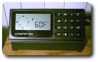
Ultimeter 2000 Weather Station
(barometer inside)
|
The source of the feed used for these pages is a
Peet
Brothers Ultimeter 2100 Weather Station, with the sensors located
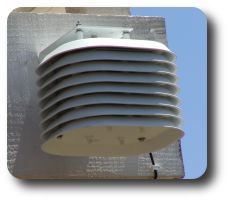
in the backyard of a Redhawk area house. The combined temperature and humidity
sensor (which replaced the original temperature only sensor in March, 2001)
is appropriately shielded from wind, moisture, and sun. It is currently mounted
on the outside of the deck approximately six feet from the rear of the house
and about eleven feet off of the ground. The sensor is a solar shielded design
for increased accuracy in adverse weather conditions. The new sensor is even
more accurate than the older sensor which was deployed in the same general
area.
|
Temperature and Humidity
Sensor (solar shielded) |
The humidity sensor produces readings within 5% of the true values,
according to Peet Brothers. The readings are adversely affected by sprinkler
activity in my yard and in neighboring yards. These effects are somewhat
mitigated by the height of the sensor (eleven feet above ground). The humidity
readings are also used to help calculate the dewpoint and the heat index. The
dewpoint calculations are derived from
code
by Jeff Clymer.
The barometric pressure sensor is integrated into the Ultimeter 2100
keyboard and it's cousin, the Ultimeter 2000. An Ultimeter 2100 has
been in used since November, 2003. From April, 2001 to November, 2003, an
Ultimeter 2000 captured data on this site. Prior to April, 2001, I used
an Ultimeter 800 keyboard which did not
include the barometer (but was otherwise identical).
The pressure
sensor actually reports a relative value; it must be
calibrated with a good value before it will operate. I used a barometric
pressure value from the Weather Channel
to calibrate it, after checking that value out against other local reports.
|
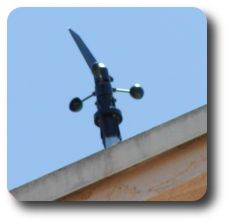
Anemometer
(wind speed and direction)
|
The wind sensor, called an anemometer, is mounted on a short (two foot)
mast located on top of the
chimney of the house. This is approximately six feet above the top of the roof.
The installation guide recommends five feet or more to avoid turbulence from the
roof. Wind data collection began in March, 2001. In addition to the wind speed and direction, wind gust speed is derived
from this sensor's readings. Wind speed is also used to help determine wind
chill.
|
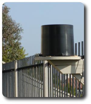
| Tipping Bucket Rain Gauge |
The precipitation sensor (an Ultimeter Tipping Bucket rain gauge)
is deployed at the edge of the backyard on the fence line.
It is a self-emptying design and is capable of
0.01 inch measurements. The precipitation
readings are very accurate with this instrument which meets National
Weather Service specifications. This rain gauge replaced a similar wireless
sensor deployed in November, 2001, which replaced the original Ultimeter Pro
wired rain gauge, deployed in November, 2000. Both prior rain gauges had to
be placed too close to the house, blocking any precipitation from the east.
The original rain gauge was plagued with regular false readings.
Precipitation data on this site began in November, 2000 and as of this writing
there are nearly two complete seasons recorded.
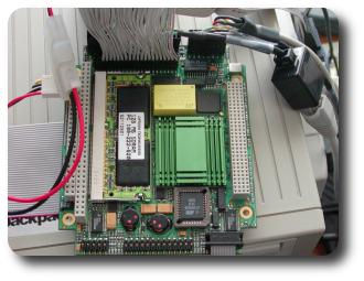
|
| Former Weather Data Capture Computer |
I began recording data nearly continuously with this system on August
25, 1999. The Ultimeter 2100 Weather Station has
several
output modes using a serial port which you can see a cord coming out of
on the side of the weather station. This system currently utilizes the
continuous output mode, which produces current weather records on the serial
port at 2400 bytes per second. A small desktop computer
captures the serial
data continuously and averages it every 30 seconds to produce a weather
record. The current computer contains a Via C3 processor, consumes less
than 30 watts of power and has been used continuously since December, 2002.
From April, 2002 to December, 2002 I utilized a a PC104+ embedded form factor computer which you can
see in the picture.
Prior to April, 2002 a
full-size PC was utilized to
capture weather data from the weather station.
The weather records are saved
and shipped every thirty seconds from this computer to the
web server, which maintains a complete archive.
There
are some gaps of a few hours here and there when the capture computer has
needed maintenance or had a bug.
Digital signatures are used to ensure that the web server is
receiving authentic data.
The archive is currently 190 megabytes in size (as of October, 2004) and
growing at the rate of about 75 kilobytes per day.
Every now and then there is a failure in the capture and posting mechanisms.
Typical sources of these problems include internet outages and sometimes
equipment failures. I currently use cable modem service for my internet
connection. This replaced wireless internet that I had used between April,
2002 and September, 2003, which in turn replaced a ISDN line
that I had used for two and a half years prior to that.
My entire setup, router/capture computer, cable modem and
the weather station itself, is backed up with UPS
equipment and should survive a power failure of four hours or more.
When an internet
outage happens and the capture computer can't communicate with the web
server, data continues to be collected and stored on the capture
computer until it can all be transfered to the web server.
A watchdog program runs regularly on the web server, checking to
see that data is still flowing, and emails me whenever there are
problems. When problems do occur, you
may see current data on the weather page that is a little out of date.
The serial capture and archival itself has proved highly reliable
and after over five years of data capture, there should be very few bugs
remaining (in fact I know of none currently). The capture software has run
for months at a time without interruption.
Code to compute sunrise and sunset times was written by
Kevin Boone.
All the software is written custom for the site by
John C. Toman.
The forecasts that appear on TemeculaWeather.com are now based on the
NWS Temecula Forecast,
which I look at daily,
produced by the National Weather Service.
I tailor this forecast slightly to the Temecula Valley
based on the observations collected by TemeculaWeather.com. Only slight
tailoring is necessary at this point in time because my weather readings so
closely
match the National Weather Service readings taken at the fire station in
Old Town Temecula. I began daily
forecasting in September, 2001 when I received emails asking me what the most
accurate forecast for the area was (the links on main page can have widely
variant forecasts). Forecasting is difficult. Most of the time we're accurate,
now and then we're not.
TemeculaWeather.com first appeared on the internet in August, 2000 and is
currently featured on the official
City of Temecula home page,
and on several other local web sites. The
National Weather Service, San Diego office
is currently using the data from WeatherCurrents sites to enhance their
forecasting.


