Currently
54°F
in Temecula, California, USA
56°F / 54°F
calm
0.00"
Wednesday, April 30, 2025 3:25 AM PDT
Temecula
Currently
Forecast
Past Weather
Climate
Last 36 Hours
Weather News
Features
About
F.A.Q.
Email Lists
Contact Us
Use °C/Metric
 RSS Feed
 Follow UsWeatherCurrents
Local Roundup
Mobile Access
On Your Site
Follow UsWeatherCurrents
Local Roundup
Mobile Access
On Your Site
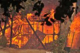
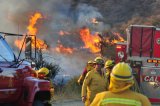
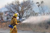
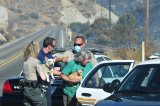
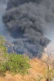
Vail Ranch Wildfire Burns 340 Acres, 6 houses destroyed (updated, photos)
Posted September 20, 2009, 4:06 PM.A wildfire quickly burned 340 acres east of Temecula Saturday afternoon, taking twelve structures and several vehicles with it, according to the Riverside County Fire Department. Highway 79 South was closed at Anza Road as a precaution Saturday night and most of Sunday. It reopened Sunday afternoon. The fire was reported at 3:52pm Saturday. 500 residents were evacuated through the reverse 911 system. The evacuation area was north of Vail Lake, to Sage Road. 115 firefighters were on hand to fight the blaze, including helicopters and air tankers. Of the twelve structures burned, conflicting reports said either 6 to 8 of those were homes. Full containment occurred Sunday evening at 6pm. The cause of the fire was reportedly an overheated catalytic converter. For more on the fire, please see the following news articles:
Vail Lake

|
Other Recent Weather News for Temecula, California
|