Currently
53°F
in Murrieta, California, USA
53°F / 50°F
calm
0.00"
Wednesday, April 30, 2025 8:08 AM PDT
Murrieta
Currently
Forecast
Past Weather
Climate
Last 36 Hours
Weather News
Features
F.A.Q.
Contact Us
Use °C/Metric
 RSS Feed
 Follow UsWeatherCurrents
Local Roundup
Mobile Access
On Your Site
Follow UsWeatherCurrents
Local Roundup
Mobile Access
On Your Site
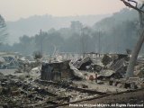
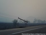
Rice Canyon Fire Photos
Posted October 27, 2007, 4:27 PM.The following are photos from the Rice Canyon Fire, which began on October 22nd in Rainbow, and spread quickly over the Interstate 15 freeway into Fallbrook. The cause of the fire was determined to be a downed power line, from Santa Ana winds that registered in the 70 mph range. Please be warned: Some of the photos we just processed will be unsettling and depressing. Many homes were lost in this fire, and the first photo in this series shows where some of them stood. While processing this particular photo, your editor was close to tears. The photo was taken by Michael Mojarro, who was on the fire lines that day, with his cell phone camera. He mentioned it as being "probably one of the most depressing days of my life." "I witnessed fire hoses still attached to fire hydrants that were burnt and charred, left from running fire fighters who attempted to save the homes," he said. Fortunately, no lives have been reported lost in the inferno. Four firefighters have been reported injured fighting this particular fire. We've received many photos, and there are many more to be processed. This story will be updated as we go through our backlog. If you have a photo related to the Rice Canyon fire, please send it in. Fallbrook
|
Other Recent Weather News for Murrieta, California
|