
N/A°F / N/A°F
N/A
N/A
Those of us who live in Temecula Valley in the winter are treated to sweeping views of snow-capped mountains in the winter and sometimes into the spring. Mt. San Jacinto to the east and Mt. San Gorgonio to the North are white delights after each storm. On clear days, abundant in Temecula winters, Old Baldy and the San Gabriel Mountains of Los Angeles county are also visible to the north. Sometimes Mt. Santa Rosa is visible in the distant east. Most winter storms also bring snow to Mt. Palomar in San Diego county, visible to the south from certain areas of the valley. From Temecula itself, the most visible mountain to the south is Agua Tibia, which blocks the view of Mt. Palomar for those in the southwest part of the Temecula Valley.
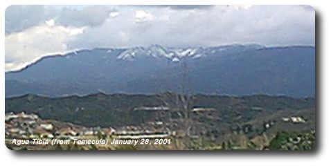
In the seven years that I've lived in Temecula, until January, 2001, I've seen snow on Agua Tibia Mountain a total of only three times. (After January, 2001, prominent snow on Agua Tibia has been more common in the winter). In recent history, seeing Agua Tibia snow is a relatively rare event. Which is why I've featured it on TemeculaWeather.com. Agua Tibia ranges in elevation from 4400 to 5077 feet at its crest, called Eagle Crag. Snow regularly gets below 4000 feet several times in any winter, so it must snow up there a few times a year. And yet the snow is visible now like never before. I think the Agua Tibia fire of August, 2000 which burned south of Temecula has made snow more visible where we couldn't see it before (later winters have proven this to be true). You can see from the picture the vast white areas covering the mountain like it has ski runs. Fires on the south and east facing sides of Agua Tibia occurred in 1989 and 1987. After last year's fire, there must not be that many pine trees and manzanita shrubs left up there.
More on Agua Tibia Mountain can be found here.
There are not very many places in Southern California with the sweeping mountain views that we enjoy in the Temecula Valley. The dramatic mountain backdrop in every direction enhances the beauty of the area. We get a daily taste of the tallest mountains in our own county and in all of our neighboring counties as well. And when they are snowcapped in the winter season, the mountain views of the valley are even more enjoyable!
See a list of all features, including fires, snow, hail and other events, on the features page.