 RSS Feed
 Follow Us
Weather Sites
Local Roundup
Anza
De Luz
Fallbrook
French Valley
Hemet
Lake Elsinore
Moreno Valley
Murrieta
Pinon Hills
Riverside (Canyon Crest)
Riverside (Presidential Park)
San Diego (City Heights)
San Jacinto
Simi Valley
Temecula
Follow Us
Weather Sites
Local Roundup
Anza
De Luz
Fallbrook
French Valley
Hemet
Lake Elsinore
Moreno Valley
Murrieta
Pinon Hills
Riverside (Canyon Crest)
Riverside (Presidential Park)
San Diego (City Heights)
San Jacinto
Simi Valley
Temecula
Storm totals: November 6th-7th, 2011
By John C. Toman. Posted November 7, 2011, 7:30 AM.
The second of two storms resulted in another rainy day on Sunday, leaving between 0.15" and 0.61" inches of rainfall in Southern California's inland valleys. The storm started with a band of light to moderate rain, and finished with a thunderstorm Sunday night, with lightning in spots and hail, especially in the San Bernardino Valley. "We enjoyed a spectacular lightning show which lasted a couple of hours," said Rick Leonard, of Beaumont, "along with some periods of hail and hard rain. At one point we had a brief power outage as well." Lightning was reported across the region on Sunday evening. At one point, hail was reported along Interstate 10 in San Bernardino County. Hemet led the way this time with 0.61", marking the second storm in a row where rainfall was heavier to the east. Other large totals were recorded in Lake Elsinore (0.52"), Riverside (0.47"), Moreno Valley (0.46") and Beaumont (0.44"). San Bernardino (0.15"), Murrieta (0.16") and Wildomar (0.17") recorded the least amounts. To the west Simi Valley recorded 0.40", nearly all of it in the early morning. Other robust late morning / early afternoon totals were more to the south, in Fallbrook (0.33"), Menifee (0.26"), and Temecula (0.25"). The following rainfall totals were recorded Sunday and Monday morning:
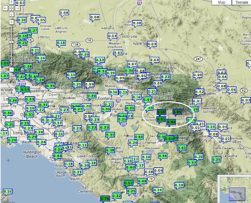
Inland storm totals (courtesy National Weather Service) |
Other Recent Weather News for WeatherCurrents
|