Currently
98°F
in Murrieta, California, USA
98°F / 59°F
1 mph E
0.00"
Friday, March 20, 2026 1:30 PM PDT
Murrieta
Currently
Forecast
Past Weather
Climate
Last 36 Hours
Weather News
Features
F.A.Q.
Contact Us
Use °C/Metric
 RSS Feed
 Follow UsWeatherCurrents
Local Roundup
Mobile Access
On Your Site
Follow UsWeatherCurrents
Local Roundup
Mobile Access
On Your Site
Older Murrieta Weather News
Editor's Note: Newer news items are available.
| January 20, 2005 | 6:55am: Reconstruction of Pala Road over Pechanga Creek is complete (south of Pechanga Casino and Great Oak High School), with four new, larger culverts installed, a widened creek bed, and boulders to hold down erosion. The road was paved yesterday and reopened. Thanks to Sue Bram for this report. | ||||||||||||||||||||||||||||
| January 15, 2005 | 9:20am: CalTrans has decided to shut down one lane of Interstate 15 northbound south of the Highway 79 exit in Temecula as a precaution, according to a story in The Californian this morning. A mudslide below the freeway onto the Temecula Creek golf course has undermined the road. A blocked drainpipe caused rainwaters to saturate the soil instead of running off. The lane may be closed two weeks while CalTrans repairs the slope. | ||||||||||||||||||||||||||||
| Other roads that remain closed include Pauba Road east of Temecula, Pala Road south of Temecula (repairs there are underway), and the Ortega Highway between Lake Elsinore and San Juan Capistrano. | |||||||||||||||||||||||||||||
| January 14, 2005 | 4:50pm: Prado Dam in the Corona area has been reportedly shored up, the mandatory evacuation has been lifted, and Highway 71 has reopened this afternoon. | ||||||||||||||||||||||||||||
| 1:45pm: There are news reports today of a minor leak in the Prado Dam, which holds back the Santa Ana River in the Corona area, near the intersections of Highway 71 and Highway 91. The area has been evacuated as a precaution, and Highway 71 is closed in both directions. | |||||||||||||||||||||||||||||
| January 10, 2005 | 11:10pm: The heavy rainfall story has been updated with more road closings, some pictures, the reopening of Highway 79 South in Temecula, other online news articles, and more. | ||||||||||||||||||||||||||||
| 1:10pm: A feature story on this weekend's heavy rainfall has been posted. | |||||||||||||||||||||||||||||
| January 9, 2005 | 10:30pm: Highway 79 South is closed again due to mud just east of Anza Road, east of the Temecula city limits. Caltrans is working on clearing the road at this hour. Rainfall this evening was some of the heaviest experienced in recent times in the Temecula Valley. Thanks to James Sappington for the report on Highway 79 South. | ||||||||||||||||||||||||||||
| 5:20pm: A particularly heavy band of rain is currently hitting the Temecula Valley, accompanied with wind gusts to 30 mph. Lightning and thunder have been reported from multiple sources, and the power in the Temecula Valley and the Menifee Valley has fluctuated with a couple of the lightning hits. WeatherCurrents' mobile site has been updated today with increased forecast information, as well as some of the past weather information. This is the first real update in quite some time. Installation of the Lake Elsinore weather station began yesterday in spite of the rain. With some luck, perhaps weather data will be on the site for Lake Elsinore as early as next weekend. | |||||||||||||||||||||||||||||
| January 6, 2005 | 9:20am: The owner and operator of
WeatherCurrents.com, John Toman, was interviewed this week
for a radio program that will air this Sunday between 7:00am and 7:30am
on local Temecula radio stations 94.5 and 103.3.
This morning's earthquake felt in
parts of southwestern Riverside County at about 6:35am was 4.4 on the
richter scale and centered in Fontana up in San Bernardino County.
See the
Southern California Earthquake Data Center for details.
Updated rainfall reports
for the Temecula Valley area for Monday and Tuesday:
|
||||||||||||||||||||||||||||
| December 31, 2004 | 11:00am: Updated rainfall reports
for the Temecula Valley area for the Tuesday's and Wednesday's storm:
|
||||||||||||||||||||||||||||
| December 30, 2004 | 1:00pm: Rainfall in the Temecula Valley in the past two months is about equal to a normal entire season. Normally, January through March is the wettest period of the year, and those three months are still ahead. Highway 79 south was reopened yesterday at around 5pm, according to a report by Jim Sappington. | ||||||||||||||||||||||||||||
| December 29, 2004 | 9:30am: The latest storm has caused mudslides, downed trees and other problems in the Temecula Valley this morning. Highway 79 south has been closed near Anza Road (at the bridge over Temecula Creek) this morning due to a mudslide. Wind gusts were in excess of 50mph in the 1am hour last night, and rainfall for the storm in in excess of three inches. Jim Sappington contributed to this report. | ||||||||||||||||||||||||||||
| December 23, 2004 | 8:30am: A serendipitous series of events in De Luz should lead to a WeatherCurrents weather site for the hills west of Temecula in early January. Sue and Dave Painter have purchased a compatible weather station and are planning on hooking it into the WeatherCurrents network after it's installed. This is great news for a few of you that have been asking over the years if we could put a station out there. It also should provide a contrast to weather in the Temecula Valley since the weather up in De Luz, La Cresta, and the Santa Rosa Plateau is generally milder than in the valley. | ||||||||||||||||||||||||||||
| December 21, 2004 | 1:12pm: 2003's Mountain fire was finally determined to have been caused by a wellhead electrical malfunction on De Portola Road, east of Temecula. | ||||||||||||||||||||||||||||
| December 10, 2004 | 12:00pm: Links to the National Weather Service's soaring forecast have been restored on all of the sites. They had been previously lost in the NWS web site redesign this past summer. | ||||||||||||||||||||||||||||
| December 9, 2004 | 11:45am: The feed from Murrieta remains down this morning but, according to the internet service provider, should be back up again later today, and hopefully without the nightly dropouts we've been experiencing. Apparently the problem has to do with a piece of solar powered equipment, but we don't have all of the details. The switchover of internet providers to DSL has been scheduled for December 21st. | ||||||||||||||||||||||||||||
| December 8, 2004 | 7:15am: The Press-Enterprise reported yesterday (note: registration required to read the story) that the fire season has officially ended in southern California, something that was widely expected after the frequent rainfall. In northern California, the fire season had been declared over in October. | ||||||||||||||||||||||||||||
| December 3, 2004 | 1:03pm: The feed from the Murrieta weather station remains down after several attempts remotely to get it resolved. The problem appears to be something with the capture computer, and an on site visit tonight should hopefully correct it. | ||||||||||||||||||||||||||||
| December 1, 2004 | 10:13pm: Frost Warning: For the third morning in a row, widespread frost is predicted in the Temecula Valley, although temperatures are predicted to be a couple of degrees warmer than the previous two mornings. | ||||||||||||||||||||||||||||
| 12:43pm: Today's low of 28.4°F is, for the second day in a row, the coldest temperature ever recorded in the Murrieta weather station's just over one year history. | |||||||||||||||||||||||||||||
| November 30, 2004 | 10:13pm: Frost/Freeze Warning: For the second morning in a row, several hours of freezing temperatures and widespread frost are predicted. | ||||||||||||||||||||||||||||
| 3:12pm: This morning was the coldest in more than two and half years in southwest Riverside County. This morning's low of 28.6°F in Temecula was the coldest since 25.4°F was recorded on January 31, 2002. Michael Mojarro reported 27.1°F in northeastern Temecula this morning. Murrieta's low was 28.7°F and Menifee Valley recorded a chilling 26.4°F. Temperatures were below freezing for several hours this morning in the Temecula and Menifee valleys. | |||||||||||||||||||||||||||||
| 6:01am: Daily internet connectivity outages from Murrieta continue to be a problem. The typical pattern is no connectivity at night for several hours until the morning, when it picks up again. The wireless internet connection in use for the past year will likely be replaced with DSL service soon as a result. | |||||||||||||||||||||||||||||
| November 29, 2004 | 8:42pm: Frost/Freeze Warning: A cold night is in store, and frost is predicted to be widespread in the Temecula Valley tomorrow morning. Currently a low temperature of 30°F is predicted, but colder temperatures in the 20's are possible. Because temperatures may be below freezing for more than a couple of hours in some spots, a freeze warning is in effect. Some sensitive plants may not survive without protection. | ||||||||||||||||||||||||||||
| November 22, 2004 | 10:20pm: More pictures have been added to the snowfall story. | ||||||||||||||||||||||||||||
| 5:50am: We've received more than seventy pictures documenting yesterday's snowfall. Time constraints have prevented many of these photos from being published, and we'll continue to update the story with new photos until we've gotten through them all. WeatherCurrents' Murrieta site received over 1,700 page visits yesterday, by far the most for a day in its short history. It was also a record day for WeatherCurrents.com. The cold weather continues to wreak havoc with the data feed from the Murrieta site, which has now been out since yesterday afternoon. The Murrieta weather station is connected to the internet via a wireless internet connection, which was up and down all day yesterday. | |||||||||||||||||||||||||||||
| November 21, 2004 | 9:30am: A feature story on this morning's snowfall in southwest Riverside County is now on the site. It will be updated with new photos and information as they come in throughout the day. | ||||||||||||||||||||||||||||
| 8:20am: Those are confirmed snowflakes, not graupel. Some hilly areas of Murrieta have reported accumulations of 4" this morning, but it won't last for long due to the warm ground. Graupel is soft hail and is often mistaken for snow; raindrops that have frozen on the way down but not solidly. | |||||||||||||||||||||||||||||
| 7:45am: Snow!? The latest storm has hit with an incredible, freak white surprise. The snow (actually it may be graupel, we will investigate) is widespread and reports have it falling since 5am all across the Temecula Valley. It's been mixed with rain since early this morning. | |||||||||||||||||||||||||||||
| November 11, 2004 | 7:50am: Rainfall reports
for the Temecula Valley for the recent storm:
|
||||||||||||||||||||||||||||
| November 9, 2004 | 9:21am: An apparent equipment malfunction has rendered temperature data from Murrieta unreliable betweeen the 8 and 9 o'clock hours this morning. We'll try to troubleshoot the problem, but data is likely down for today until later tonight. | ||||||||||||||||||||||||||||
| 6:25am: Once again, if you've recorded rainfall from Sunday and Monday's storm, please submit your totals and we will publish them here tonight. Please include your location (including major cross streets). | |||||||||||||||||||||||||||||
| November 5, 2004 | 11:20am: The Menifee Valley weather site, serving the Menifee/Sun City area, has been released. | ||||||||||||||||||||||||||||
| November 2, 2004 | 6:30am: The offshore wind event yesterday was fairly mild as they go, with maximum wind gusts reaching only 22 mph in Temecula, 27 mph in Murrieta, and 21 mph in the Menifee Valley.The winds seem to have peaked yesterday afternoon. | ||||||||||||||||||||||||||||
| October 30, 2004 | 9:05am: Revised rainfall reports
for the Temecula Valley and Wildomar (added Wildomar this morning):
|
||||||||||||||||||||||||||||
| October 28, 2004 | 7:50am: If you've recorded rainfall from this past storm, please submit your totals and we will run them here perhaps tomorrow. Please include your location (including major cross streets). Also, any storm-related pictures would be appreciated; a feature story on the record October rainfall is coming soon. | ||||||||||||||||||||||||||||
| 6:30am: An early morning thunderstorm has left nearly half an inch of rain in Temecula and Fallbrook, and a lesser amount in Murrieta, and may have woken some people early. | |||||||||||||||||||||||||||||
| October 27, 2004 | 9:40pm: Today's rainfall total of 2.17" so far is the most ever recorded by TemeculaWeather.com in its five year history, beating 1.99" on February 25, 2003. Today's total of 3.06" in Murrieta is the highest one day rainfall recorded by any of WeatherCurrents' sites. | ||||||||||||||||||||||||||||
| 6:45am: Areas susceptible to flooding will likely be flooded this morning after heavy rainfall this morning. Exercise care driving today; conditions will be treacherous. | |||||||||||||||||||||||||||||
| October 27, 2004 | 9:40pm: Today's rainfall total of 3.06" in Murrieta is the highest one day rainfall recorded by any of WeatherCurrents' sites. Temecula's 2.17" today was the highest in its five year history. | ||||||||||||||||||||||||||||
| 6:45am: Areas susceptible to flooding will likely be flooded this morning after heavy rainfall this morning. Exercise care driving today; conditions will be treacherous. | |||||||||||||||||||||||||||||
| October 25, 2004 | 3:50pm: This past weekend we began showing sunrise and sunset information on all WeatherCurrents sites. This information is located in the "Currently" section on each main page, underneath "Temperature, Humidity, Wind & Pressure". There is some (but very little) variability of times between the various communities. Note that the times are based on a flat horizon. Hills in some communities will cause the actual sunrise to be later and the actual sunset to be sooner. | ||||||||||||||||||||||||||||
| October 22, 2004 | 3:35pm: After a week of wet weather and between 2 and 5 inches of rain in San Diego and Riverside counties, fire season in the northern part of California has been declared over, but fire units are still on alert in our region. Fire officials are warning that one strong Santa Ana wind event could dry out vegetation. We've also finally released a chronology of significant wildfires in Southwest Riverside County and the Fallbrook area. | ||||||||||||||||||||||||||||
| October 18, 2004 | 10:15am: New today is the current local weather roundup page. For those who would like to see current information for all of WeatherCurrents' weather sites, including temperatures, rainfall and wind data, the new page offers a convenient one stop summary. | ||||||||||||||||||||||||||||
| October 15, 2004 | 3:15pm: The National Weather Service has updated their forecast for this weekend. Rain is likely west of the mountains for late Saturday night and Sunday morning. Up to half an inch is possible. A tropical system is being tracked, and if moisture from it mixes in, totals could be higher. | ||||||||||||||||||||||||||||
| October 8, 2004 | 9:55am: The National Weather Service links have been updated to new equivalents, where possible. They'd all broken earlier this week as a result of a web site reorganization. Gone for now is the soaring forecast; it'll be restored as soon as we can figure out where it went. | ||||||||||||||||||||||||||||
| September 19, 2004 | 3:43pm: For those who have been patiently waiting, activity regarding the Wildomar site has finally gotten underway once again. Hopefully, installation will occur in October. Also, installation of the Sun City/Menifee site begins next weekend. | ||||||||||||||||||||||||||||
| September 11, 2004 | 11:00am: Today is the third anniversary of the September 11th terrorist attacks on our nation. So many ordinary people made sacrifices that day to save others. We will never forget. | ||||||||||||||||||||||||||||
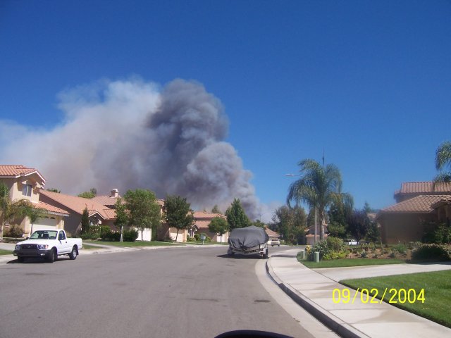
| September 2, 2004 | 4:20pm: The wildfire southeast of Temecula today has been named the Morales Fire. 200 acres of vegetation have been consumed, and it is 50% contained as of this hour. 141 firefighters are reportedly on the scene. The fire is currently moving northeast, and containment is expected tonight around 10pm. A picture, courtesy of Greg Turbeville, captures the smoke plume from the fire from the Redhawk area at about 2:30pm. | ||||||||||||||||||||||||||||
| August 31, 2004 | 7:38am: WeatherCurrents' Murrieta site received its 100,000th viewing early this morning, crossing the milestone not even a year into its existence. Thanks to all who regularly visit this site and make its success possible. | ||||||||||||||||||||||||||||
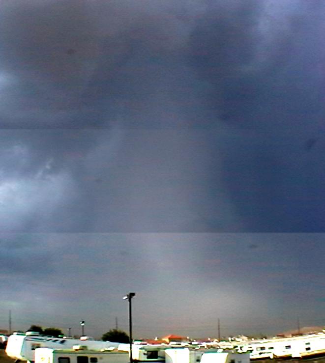
| August 26, 2004 | 4:45pm: This composite picture of a funnel cloud (which reportedly touched ground and became a Tornado) was taken by Shaun Brodie in the Menifee Valley during the thunderstorms of Friday morning, August 13th. | ||||||||||||||||||||||||||||
| August 13, 2004 | 3:03pm: Thunderstorms were reported around the Temecula Valley, Hemet and beyond this morning. Michael Mojarro reports a 1" dumping at his home in the north part of Temecula. Katy Parkhurst up in Sun City reports 1/2" of rainfall. South Temecula, where this station is located, hasn't received any rainfall, and only a little rainfall has been recorded up in northwest Murrieta, where the Murrieta station is located. Thunderstorms and rainfall have also been reported in Hemet. | ||||||||||||||||||||||||||||
| July 31, 2004 | 9:58am: This morning's eight hour service outage was caused by faulty software on the web server. Apologies if you were trying to access the web server before 8:30am this morning, when the problem was resolved. | ||||||||||||||||||||||||||||
| July 23, 2004 | 11:20am: A story on the Citrus wildfire near Hemet has been posted on the Hemet site. | ||||||||||||||||||||||||||||
| 6:19am: The Murrieta data feed is down since yesterday afternoon. The cause is unknown but it will be restored at the soonest opportunity. | |||||||||||||||||||||||||||||
| 6:11am: Yet another fire has been reported, this one much nearer to Hemet, close to the Valle Vista area. Control was expected this morning on a 765 acre wildfire called the Citrus fire. No structures have been burned, but one firefighter has received burn injuries and two others have been treated for exhaustion. One home was evacuated. The cause of the Citrus fire is also under investigation. Photos have been submitted and more information will be posted later this morning on the Hemet site. | |||||||||||||||||||||||||||||
| July 22, 2004 | 9:25am: California Department of Forestry and Fire Protection (CDF) is reporting the Martin fire to be 150 acres in size and 15% contained. No structures are currently threatened. It started 9:30pm last night northeast of Sage and Red Mountain Roads. The cause is under investigation. | ||||||||||||||||||||||||||||
| 8:48am: A new wildfire called the Martin fire has reportedly burned 135 acres near Sage, south of Hemet. It started last night near Martin Road. | |||||||||||||||||||||||||||||
| July 19, 2004 | 9:20am: The Melton fire story has been updated. The current footprint of the blaze is 3,600 acres and it is a reported 50% contained. | ||||||||||||||||||||||||||||
| July 18, 2004 | 2:00pm: The Melton fire story has been updated. Mandatory evacuation orders have been lifted. The fire is 3,219 acres in size and 20% contained, and firefighters have apparently gained the upper hand. | ||||||||||||||||||||||||||||
| 12:23am: Photos and a story about the Melton fire, which has reportedly burned 7,000 acres south of Hemet near Sage, is now online. Sage is well east of the Murrieta city limits. | |||||||||||||||||||||||||||||
| July 15, 2004 | 9:05am: The Fallbrook site is finally available. Custom graphics are still to come. | ||||||||||||||||||||||||||||
| July 8, 2004 | 11:22am: There are some thunderstorms floating around the region this morning and some light showers have been reported in the L.A. area. It's possible some of these may reach the Temecula Valley. | ||||||||||||||||||||||||||||
| July 1, 2004 | 10:44pm: Correction on the fire: it is south of Temecula near the Pala Indian Reservation, and has been named the Pala Fire. 200 acres have been reported burned near Route 76, but fire crews are apparently quickly containing this one. No structures are currently threatened. | ||||||||||||||||||||||||||||
| 5:33pm: A fire has been reported near the San Diego County line, out past Aguanga and near Warner Springs. This puts it southeast of the Temecula Valley, but smoke is clearly visible from the valley. Reports have called the fire "significant" but there aren't a lot of details at this point. | |||||||||||||||||||||||||||||
| June 26, 2004 | 4:00pm: Fallbrook update: The wind sensor is still not connected and graphics aren't complete, but the rest of the Fallbrook weather site is operating and has been sending data. The mobile site has been launched today; the web site launch has been delayed again and will be after Independence Day. | ||||||||||||||||||||||||||||
| June 15, 2004 | 4:57pm: Today's magnitude 5.2 earthquake, 60 miles west of Tijuana and four miles deep under the ocean, was felt all over the region, including Temecula and Murrieta. The quake occurred at approximately 3:30pm. For raw information, see this local USGS map. | ||||||||||||||||||||||||||||
| June 5, 2004 | 11:35pm: Temperature data from Fallbrook is now online. However, the official launch of the Fallbrook site is between two and three weeks away. | ||||||||||||||||||||||||||||
| May 29, 2004 | 11:03am: Installation of a weather station in the Fallbrook area begins this afternoon. An official unveiling of the Fallbrook weather site won't be until the middle of June, however. Thanks to Tom Chester of Fallbrook for volunteering to host the equipment. | ||||||||||||||||||||||||||||
| May 21, 2004 | 12:50pm: WeatherCurrents web sites will be down between 10pm and 11pm tonight for scheduled maintenance. | ||||||||||||||||||||||||||||
| May 3, 2004 | 10:00pm: Updated information and pictures for the Eagle Fire has been made available. | ||||||||||||||||||||||||||||
| 10:45am: An outage last night and this morning appears to have involved weather data collection. Several hours of data have been unfortunately lost. The data stream is back up now, but for currently unknown reasons humidity is still down. | |||||||||||||||||||||||||||||
| May 2, 2004 | 11:03pm: Information and photos for the Eagle Fire, in the southwestern part of the Temecula Valley, is available from the Temecula web site. | ||||||||||||||||||||||||||||
| April 27, 2004 | 8:46am: Yesterday's highs of 101.5°F in Temecula and 97.2°F in Murrieta were by far the hottest April temperatures on record (Temecula's previous April hottest was 93.2°F on April 26, 2000). Yesterday's high in Murrieta was the hottest temperature recorded since that station began operation in November of last year. | ||||||||||||||||||||||||||||
| April 18, 2004 | 10:57am: Yesterday's rainfall totals of 0.31" in Temecula and 0.23" in Murrieta put the Temecula Valley over the 9" mark for the season (Murrieta is a little short, but doesn't have a complete season recorded and would likely be close to 10" if it did). The wettest months of the year are behind us at this point; based on past results, the chances of even an inch more of rainfall before the season close are small. | ||||||||||||||||||||||||||||
| April 1, 2004 | 6:17pm: April's first showers arrived unexpectedly today and more are on the way, if the revised forecasts are any different than the ones that totally missed rainfall this morning. | ||||||||||||||||||||||||||||
| March 27, 2004 | 12:05pm: A long-delayed feature on the winter storms this year has finally been posted. | ||||||||||||||||||||||||||||
| March 23, 2004 | 6:15am: A power outage in the neighborhood of the Murrieta weather station is scheduled for between 9:30am and 3:30pm today, and may temporarily affect capture and transmission of weather data to the web site. | ||||||||||||||||||||||||||||
| March 20, 2004 | 11:20am: Revised dates for the Wildomar and Fallbrook weather sites are April and May, respectively. | ||||||||||||||||||||||||||||
| March 17, 2004 | 6:22am: The Hemet station has had an equipment breakdown and hasn't been able to capture or transmit any weather data since Sunday morning. Spare parts are on the way and it should be back up within the next couple of days. | ||||||||||||||||||||||||||||
| March 7, 2004 | 11:09am: In response to multiple requests, rainfall by hour is now available for individual days under the Past Weather section. | ||||||||||||||||||||||||||||
| March 6, 2004 | 10:45am: A new forecast backend begins operation today. You shouldn't notice any real differences on the main page, but it makes it much easier to enter forecast data into the system. | ||||||||||||||||||||||||||||
| March 1, 2004 | 6:16am: The Hemet weather site became available yesterday evening. | ||||||||||||||||||||||||||||
| February 28, 2004 | 5:16pm: Opening of the Hemet site is delayed until tomorrow. For those interested, it should finally be ready sometime tomorrow afternoon. | ||||||||||||||||||||||||||||
| February 27, 2004 | 5:20pm: The WeatherCurrents server will be unavailable tonight at approximately 10pm while maintenance is performed. | ||||||||||||||||||||||||||||
| February 22, 2004 | 1:36pm: Southern Temecula has experienced a couple of fierce downpours, as well as thunder and lightning, in the past couple of hours, and rainfall is quickly heading for the 1.5" mark for the day. Interestingly, northwest Murrieta is not experiencing the same torrential showers this afternoon, nor is Hemet. Both of those areas have winds blowing from the east, which may account for the relatively smaller rainfall totals. | ||||||||||||||||||||||||||||
| 10:37am: An update on upcoming weather sites: The Hemet weather site will make its debut this upcoming Saturday, February 28th. The Wildomar and Fallbrook weather sites have been slightly delayed, but all of the equipment is now in and being prepped and we're hoping to have them both up and operating sometime next month. | |||||||||||||||||||||||||||||
| February 14, 2004 | 11:19am: I've received one report of ice pellets (or graupel) falling in the Temecula Valley this morning, on Calle Medusa in northeast Temecula. This is a little like hail except soft. Thanks Michael Mojarra for reporting this. He reports that it looks like sleet. Snow levels are down to 3000 feet this morning, and more weird stuff may occur. We'd appreciate any photos anyone might have of this. | ||||||||||||||||||||||||||||
| February 11, 2004 | 6:04am: The Hemet data feed may begin as early as tonight. If so, at least the current temperature should be available under the local weather roundup of both the Temecula and Murrieta main pages. All of the equipment has come in for Wildomar and Fallbrook has come in and installation of the weather stations at those sites should begin shortly. | ||||||||||||||||||||||||||||
| February 7, 2004 | 9:48am: There's a new featured photo this morning, and the rules have been changed for submissions. Previously, a selected photo would run at least two weeks before replacement; now we'll run more than one at a time if there are multiple submissions selected. | ||||||||||||||||||||||||||||
| January 31, 2004 | 10:40am: A relatively dry January is drawing to a close, with only about 1/2" of rainfall in both Temecula and Murrieta. This is nothing new, though, as the Temecula Valley also experienced dry Januaries in 2002 and 2001. February, on the other hand, has a tendency to be very wet, the wettest month of the year on average, with over 5" recorded in Temecula in 2003 and 2001 (but a measly 0.19" in 2002). | ||||||||||||||||||||||||||||
| January 23, 2004 | 6:04am: If you've got a recent picture taken from Murrieta or the surrounding areas (excluding Temecula), please submit it. I'm looking to replace the current featured photo soon. | ||||||||||||||||||||||||||||
| January 15, 2004 | 7:59pm: Update on the outage: internet access equipment has failed in Murrieta and is awaiting repair, which is probably tomorrow. In the meantime, the weather records are queueing up for transfer. When internet access is restored, all of the data for the past 11 hours or so plus data to be recorded still will flow to the site. | ||||||||||||||||||||||||||||
| 6:10am: Homes have been found for the upcoming Hemet and Fallbrook weather sites. Hemet will take advantage of an existing weather station already in operation there. Fallbrook will be a new installation about three miles south of downtown in the Winterwarm area. I currently expect to have the Wildomar, Hemet and Fallbrook weather pages operating before April of this year. Something has thrown the Murrieta weather feed offline since yesterday afternoon. I was unable to contact the host home to find out what has happened, but will resume trying later this morning. | |||||||||||||||||||||||||||||
| January 11, 2004 | 10:34am: The Murrieta weather station console was accidentally unplugged for two hours yesterday afternoon, between 1 and 3 pm. Unfortunately this means that no data was recorded in that period, but Ted MacKechnie thinks we captured the high for the day despite this. | ||||||||||||||||||||||||||||
| January 10, 2004 | 11:23am: This afternoon I'm investigating a potential site for the Wildomar weather station. If the site is suitable, the third station in the area may be installed in February. The site redesign for Temecula (along the lines of this site) has been delayed a little pending graphics but hopefully will be completed soon. I've been contacted about the upcoming Menifee site as well but so far the qualifications haven't been met. | ||||||||||||||||||||||||||||
| January 1, 2004 | 9:53am: 2003 was a momentous year for WeatherCurrents and its two sites in Temecula and Murrieta. 2003 was the year a lot of the behind the scenes software was rewritten, and this allowed the launch of the second WeatherCurrents site in Murrieta this past month. The big weather-related events for 2003 in the Temecula Valley included a hailstorm on February 20th, the tragic Mountain Fire on October 26th, and a funnel cloud on November 12th. The number of visitors to the web sites has continued to climb. The Temecula site peaked at 4,518 page views on October 28th, and now averages over 1,400 page views per day, and even the brand new Murrieta site was averaging almost 400 page views a day by year end. 2004 should see some new features and additional, expanded local weather coverage. Temecula, and perhaps Murrieta, may get web cams if experiments are successful. The Temecula site is going to get a new look very soon. Other new features being considered include an expanded forecast, graphs, sunrise and sunsets, and moon phases. New local sites may be added all around the Temecula Valley, in places like Menifee, Wildomar, Fallbrook, French Valley, Lake Elsinore, and Hemet and perhaps beyond. Some of those sites are only held up right now pending locations in those communities. | ||||||||||||||||||||||||||||
| December 28, 2003 | 7:20am: Christmas Day's 2.45" has been confirmed by other measurements in the yard where the weather equipment is by Ted MacKechnie. Amazing; that's the most a WeatherCurrents rain gauge has ever recorded in a 24 hour period. | ||||||||||||||||||||||||||||
| December 27, 2003 | 7:20am: Christmas Day's 2.45" has been confirmed by other measurements in the yard where the weather equipment is by Ted MacKechnie. Amazing; that's the most a WeatherCurrents rain gauge has ever recorded in a 24 hour period. | ||||||||||||||||||||||||||||
| December 27, 2003 | 8:47am: Steve Gorchoff reports 1.5" at his home in west central Murrieta for the Christmas Day storm, so based upon the foothill location of the WeatherCurrents site, the 2.46" may be legitimate. Suffice to say that most parts of Murrieta received less rain than that. When I get a chance, I'll place a manual rain gauge at the Murrieta site to verify. | ||||||||||||||||||||||||||||
| December 26, 2003 | 8:03am: More service interruptions yesterday amid heavy rainfall. Rainfall looks to have particularly heavy in northwestern Murrieta yesterday. I'm attempting to verify the precipitation total with Steve Gorchoff, who lives in the western central Murrieta and has provided WeatherCurrents with his high/low/precipitation records dating back to 2000. Those records will soon appear on this site. | ||||||||||||||||||||||||||||
| December 24, 2003 | 9:18am: Some mornings it appears that the wireless ISP in Murrieta is cutting out for a while. Early this morning there were two data feed interruptions. | ||||||||||||||||||||||||||||
| December 20, 2003 | 10:05am: A brief outage from Murrieta in the 3 o'clock hour yesterday was quickly resolved. Look for a new featured photo sometime this morning. | ||||||||||||||||||||||||||||
| December 17, 2003 | 9:24am: The Press-Enterprise published this article about me today in their Southwest County Edition. Unfortunately, registration is required to read it on the web, but there is no cost to do so. | ||||||||||||||||||||||||||||
| 6:05am: Several more of the secondary pages were added overnight. There is little content on them as yet since the Murrieta site is so young. I fielded interviews from both the Press-Enterprise and The Californian yesterday and stories may appear today. | |||||||||||||||||||||||||||||
| December 16, 2003 | 11:18am: A press release has been written on the release of the new Murrieta site. | ||||||||||||||||||||||||||||
| December 13, 2003 | 7:19pm: This page is done, and although several secondary pages remain to be completed, WeatherCurrents' Murrieta site is open for business. For the time being, Murrieta will borrow Temecula's forecast and also its forecast icons (new ones are being designed and aren't yet ready). | ||||||||||||||||||||||||||||
| December 13, 2003 | 10:07am: The Murrieta data feed is finally back up, and all of the data for the past day has come through. | ||||||||||||||||||||||||||||
| December 12, 2003 | 8:53am: The feed from Murrieta is currently down since last night. The weather station hosts are undergoing an internet service provider change, and this is part of it. Hopefully it will be back up sometime this morning. | ||||||||||||||||||||||||||||
| December 4, 2003 | All the equipment is now installed and live weather data is flowing since November 14th. Precipitation data capture began November 22nd with the installation of the rain gauge. Wind data capture began December 3rd. The weather station is located in the northwestern part of the city, about a mile from Murrieta Valley High School, close to the western hills. |